Kastner Group members Dustin Richmond, Perry Naughton, and Ryan Kastner were among a group of researchers documenting cultural heritage at the Maya site El Zotz in the Peten region of Guatemala. The team, which also included members from Engineers for Exploration and the Explorers Club, used ground lidar, imagery from unmanned aerial vehicles, and structure from motion to provide precise data of the temples, stelae, bowls, tunnels, and masks throughout the site from the Early Classic period. The site is named “Zotz” (the Maya name for “bat”) after the thousands of bats that emerge every night from a nearby cliff. Our team was also able to provide a 3D image of that cliff and determine the location of the bat cave. Additionally, we created 3D models of the excavated tunnels beneath two the main temples, El Diablo and M7-1.
After getting the blessing from the Guatemalan government, the results of these expeditions were written up by Calit2, put on the front page of the UCSD website and the Jacobs School website, picked up by Phys.org, Gizmodo, and International Business Times.
-
- Imaging a chultun
-
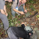
- Setting up a lidar near a mask
-
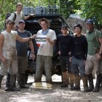
- Group shot
-

- Welcome to Zotz
-

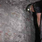
- Albert and Ryan
-
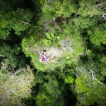
- Aerial shot from above Temple M7-1